You are viewing a US Realty Records Sample Property Report.
This property report is for display purposes only. Information in this report should not be deemed up-to-date or reliable, and some features have been disabled. Start a new search to get your own property record.
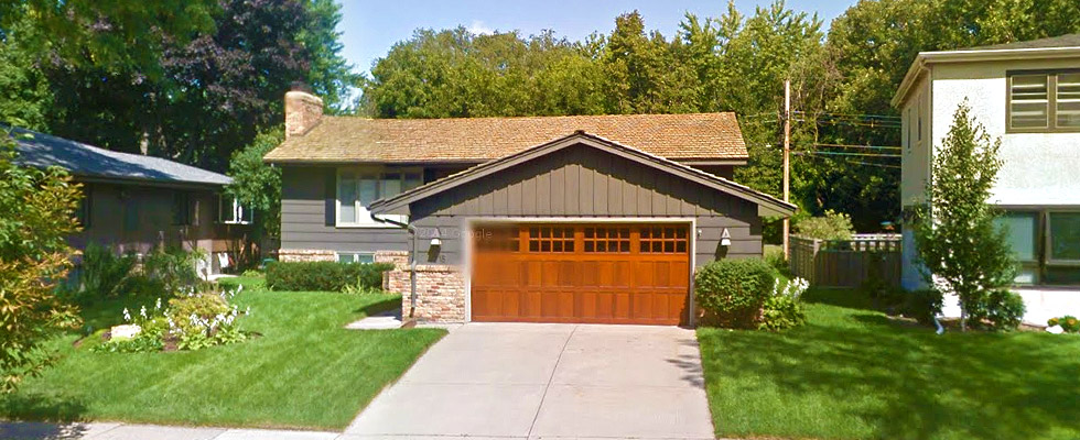
4718 Coffey Ln Minneapolis, MN, 55406
$347,536
3 Bedrooms • 2 Bathrooms • 2,156 Square Ft. • Year Built: 1965
Valuation Breakdown
Estimated Value
$347,536
?
Estimated Value
US Realty Records takes the values of surrounding properties as well as other factors to create a price-range. Our Estimate lies in between the high and low valuations to give you a more accurate estimate. Our estimate is not an appraisal and should be used as a starting point to determine a home's value.
We’re 90% confident that the actual market value lies between the low and high numbers.
USRealtyRecords.com property valuations are calculated from a variety of sources. The confidence rating shown is based on how recent and reliable these sources are.
Mortgage Calculator
Property Details
Structure Information
| Year Built | 1965 |
| Rooms Count | 7 |
| Beds Count | 3 |
| Baths Count | 2 |
| Half Baths Count | 1 |
| Full Baths Count | 1 |
| Stories Count | 1 |
| Total Size | 2,156 sq ft. |
| Finished Size | 2156 |
| Basement Size | 1,232 sq ft. |
| Exterior Wall Type | Wood |
| Basement Type | Finished |
| Building Type | Single Family |
| Category | Single family |
| Condition | Average |
| Construction Type | Wood |
| Fireplace Count | 2 |
| Garage Type | Attached |
| Heating Type | Forced Air |
| Parking Type | Attached Garage |
Property Owner History (3)
Current Owner:
Manning Desiree
Previous Owner:
Manning Desiree T & Manning Michael M
4718 Coffey Ln,
Minneapolis, MN,
55406
Previous Owner:
Lindahl-Urben Beth
Site & Jurisdiction
| Street Number | 4718 |
| Street Name | Coffey |
| Street Suffix | Ln |
| City | Minneapolis |
| Census Tract | 110500 |
| County Fips | 27053 |
| County Name | Hennepin |
| State | MN |
| Zipcode | 55406 |
| Zipcode Plus Four | 3642 |
| Zoning | R1 |
| Zoning Category | Residential |
| Zoning Description | Single Family Residence |
| Depth | 105 |
| Width | 57 |
| Size | 6,098 sq ft. |
| Acres | 0.14 |
| Range | 23 |
| Township | 28 |
| Section | 08 |
| Building Count | 1 |
| Parcel Id | 0802823220015 |
| Tax Account Id | 08-028-23-22-0015 |
Congressional District:
Congressional District 5
Upper State Legislative District:
State Senate District 63
Lower State Legislative District:
State House District 63A
Police Jurisdiction:
|
Name
Minneapolis Police Department |
Type
City |
City
Minneapolis |
Elementary School District:
|
Type: Unified
School District Not Defined |
Grades
PK - 12 |
Distance
0.05 miles |
Secondary School District:
|
Type: Unified
School District Not Defined |
Grades
PK - 12 |
Distance
0.05 miles |
Fire Jurisdiction:
|
Department Type: Career
Minneapolis Fire Department 350 S 5th ST RM 230, Minneapolis, MN, 55415 P: 612-673-2890 Visit Website |
Stations Count
19 |
Career Fire Fighters Count
423 |
Our Data:
We search hundreds of data points from many different sources. If the piece of information you are looking for doesn’t show on this report, it was not available.
Financial History
Sale History
Mortgage History
Tax History
| Year: | Taxes: | Land: | Improvements: | Total Assessment: |
|---|---|---|---|---|
| 2016 | $5,709 | - | - | $358,430 |
| 2015 | $5,995 | - | - | $358,430 |
| 2014 | $5,767 | - | - | $358,430 |
* The tax information above may not be used to determine tax payments, or for legal purposes. Please consult your local tax assessment authority for verification.
Important Tip:
Click on the tabs in this section to switch between sale, mortgage, and tax history information.
Comparable Properties
Expert Tip:
Using other properties in the neighborhood will give you an accurate measure to judge this properties worth.
Click on a property icon ![]() within the map to view estimated value and full address.
within the map to view estimated value and full address.
Neighborhood Demographics
Health Statistics
Life Expectancy Rates
Life expectancy of the region's population broken down by year and gender.
| 1985 |
Male
73
|
Female
79
|
| 1990 |
Male
74
|
Female
80
|
| 1995 |
Male
74
|
Female
80
|
| 2000 |
Male
76
|
Female
81
|
| 2005 |
Male
78
|
Female
82
|
Obesity Rates
Percentage of the region's population who are classified as obese broken down by year and gender.
| 2001 |
Male
22%
|
Female
25%
|
| 2009 |
Male
28%
|
Female
30%
|
| 2011 |
Male
28%
|
Female
30%
|
Physical Activity Rates
Percentage of the region's population who are physically active broken down by year and gender.
| 2001 |
Male
64%
|
Female
54%
|
| 2009 |
Male
63%
|
Female
58%
|
| 2011 |
Male
63%
|
Female
60%
|
Diagnosed Diabetes Rates
Percentage of the region's population with diagnosed diabetes broken down by gender and year.
| 1999 |
Male 5%
|
Female 4%
|
| 2000 |
Male 5%
|
Female 4%
|
| 2001 |
Male 6%
|
Female 4%
|
| 2002 |
Male 6%
|
Female 5%
|
| 2003 |
Male 6%
|
Female 5%
|
| 2004 |
Male 6%
|
Female 5%
|
| 2005 |
Male 7%
|
Female 5%
|
| 2006 |
Male 7%
|
Female 5%
|
| 2007 |
Male 7%
|
Female 6%
|
| 2008 |
Male 7%
|
Female 6%
|
| 2009 |
Male 7%
|
Female 6%
|
| 2010 |
Male 8%
|
Female 6%
|
| 2011 |
Male 8%
|
Female 6%
|
| 2012 |
Male 8%
|
Female 6%
|
Controlled Diabetes Rates
Percentage of the region's population with controlled diabetes broken down by gender and year.
| 1999 |
Male 24%
|
Female 32%
|
| 2000 |
Male 25%
|
Female 32%
|
| 2001 |
Male 24%
|
Female 31%
|
| 2002 |
Male 24%
|
Female 32%
|
| 2003 |
Male 24%
|
Female 31%
|
| 2004 |
Male 24%
|
Female 31%
|
| 2005 |
Male 24%
|
Female 30%
|
| 2006 |
Male 24%
|
Female 31%
|
| 2007 |
Male 24%
|
Female 31%
|
| 2008 |
Male 24%
|
Female 31%
|
| 2009 |
Male 25%
|
Female 31%
|
| 2010 |
Male 25%
|
Female 31%
|
| 2011 |
Male 25%
|
Female 31%
|
| 2012 |
Male 25%
|
Female 31%
|
Binge Alcoholism Rates
Percentage of the region's population with binge alcoholism broken down by gender and year.
| 2002 |
Male 28%
|
Female 13%
|
| 2003 |
Male 27%
|
Female 13%
|
| 2004 |
Male 26%
|
Female 13%
|
| 2005 |
Male 25%
|
Female 13%
|
| 2006 |
Male 25%
|
Female 13%
|
| 2007 |
Male 25%
|
Female 13%
|
| 2008 |
Male 27%
|
Female 14%
|
| 2009 |
Male 28%
|
Female 16%
|
| 2010 |
Male 27%
|
Female 16%
|
| 2011 |
Male 29%
|
Female 17%
|
| 2012 |
Male 29%
|
Female 17%
|
Heavy Alcoholism Rates
Percentage of the region's population with heavy alcoholism broken down by gender and year.
| 2005 |
Male 9%
|
Female 7%
|
| 2006 |
Male 9%
|
Female 7%
|
| 2007 |
Male 9%
|
Female 8%
|
| 2008 |
Male 11%
|
Female 8%
|
| 2009 |
Male 10%
|
Female 9%
|
| 2010 |
Male 10%
|
Female 9%
|
| 2011 |
Male 12%
|
Female 11%
|
| 2012 |
Male 12%
|
Female 10%
|
Nearby Schools
Having great schools near the property can help to stablize the property’s value. It is typical for properties with good surrounding schools to hold their value better. Additionally, good schools help the saleability of the property.
| School | District | Grade Range | Distance |
|---|---|---|---|
|
Type: Private
Highland Catholic School 2017 Bohland Avenue, Saint Paul, MN 55116 |
- | PK-8 | 1.74 Miles |
|
Type: Public
Horace Mann School 2001 Eleanor Ave, St. Paul, MN 55116 |
St. Paul Public School District | K-6 | 1.74 Miles |
|
Type: Charter
Friendship Acdmy Of Fine Arts Chtr. 2600 East 38th St,Minneapolis, MN 55406 |
Friendship Acdmy Of Fine Arts Chtr. | - | 1.93 Miles |
|
Type: Public
Wellstone International High School 4029 28th Av South,Minneapolis, MN 55406 |
Minneapolis Public School Dist. | - | 1.93 Miles |
|
Type: Public
Roosevelt Senior High School 4029 28th Ave South,Minneapolis, MN 55406 |
Minneapolis Public School Dist. | - | 1.93 Miles |
|
Type: Private
St Paul Academy - Summit 1712 Randolph Avenue, Saint Paul, MN 55105 |
- | K-12 | 2.8 Miles |
|
Type: Charter
Leadership Academy 2872 26th Ave South,Minneapolis, MN 55406 |
Minnesota Transitions Charter School | - | 2.85 Miles |
|
Type: Charter
Minnesota Transitions Middle School 2872 26th Ave South,Minneapolis, MN 55406 |
Minnesota Transitions Charter School | - | 2.85 Miles |
|
Type: Public
Folwell Middle School 3611 20th Ave South,Minneapolis, MN 55407 |
Minneapolis Public School Dist. | - | 2.89 Miles |
|
Type: Charter
Laura Jeffrey Academy Charter 1550 Summit Ave,St. Paul, MN 55105 |
Laura Jeffrey Academy Charter | - | 2.96 Miles |
Nearby Features
Map Legend:
 Fire Department Fire Department |
 Police Station Police Station |
 Hospital Hospital |
 Post Office Post Office |
 Library Library |
 Museum Museum |
 Shopping Shopping |
 Park Park |
 Natural Natural |
 Other Features Other Features |
Walk Score
Climate Insights
Probability of Natural Disasters

Flooding
Events since 1980: 40

Wild Fires
Events since 1980: 0
Earth Quakes
Events since 1980: 0

Tornadoes
Events since 1980: 9
Hurricanes
Events since 1980: 0
Land Slides
Events since 1980: 0

Snow/Ice/Hail
Events since 1980: 429
Extreme Heat
Events since 1980: 7
Heavy Wind
Events since 1980: 228
Storm Events
Heavy Rain 12-JUN-16 15:00:00 to to 12-JUN-16 18:00:00
A rainfall report of 2.80 inches occurred north of Brooklyn Park in less than 6 hours.
Winter Storm 02-FEB-16 13:00:00 to to 03-FEB-16 05:00:00
Several sources from local spotters, and officials indicated that heavy snow fell across the county. Locally, 6 inches of snow fell in the southern part of the county with occasional light snow and blowing snow through early Wednesday morning.
Extreme Cold/Wind Chill 17-JAN-16 04:00:00 to to 17-JAN-16 08:00:00
Several sources of weather observations indicated that wind chill values dropped to around -35F for a few hours.
Thunderstorm Wind 17-JUL-15 23:30:00 to to 17-JUL-15 23:45:00
A large bow echo surged across eastern Hennepin County causing numerous downed trees and power lines. Some of the trees were 12 inches in diameter. There were also several measured reports of severe wind gusts from private weather stations in Hennepin County. One measured wind gust was 58 knots. In addition, the Spirit of the Lakes Festival had shelters and tents blown down. The Spring Park City Hall had a tree blown down. At one point, 33,000 Xcel Energy customers were out of power in Hennepin County.
Hide/Show DetailsSeveral severe thunderstorms developed in northeast South Dakota during the late afternoon of Friday, July 17th. These storms moved slowly initially across northeast South Dakota where severe wind gusts, very large hail and a tornado occurred. ||After 730 PM CST, these severe storms began to bow out across west central Minnesota from Morris, southwest to Ortonville. Severe wind gusts were reported in Madison to Appleton City as the bow echo began to accelerate eastward across southern Minnesota.||Numerous reports of downed trees, power lines and occasional hail occurred from the South Dakota, Minnesota border eastward to the Twin Cities, and into west central Wisconsin. ||Damage was more sporadic in western Minnesota, but became more widespread in eastern Minnesota as a more intense bow echo developed. A widespread area of trees and power lines were blown down across the Twin Cities metro area, with some areas measuring wind gusts up to 61 knots. ||One of the bow echo segments produced a brief tornado west of Watertown, where a storm survey indicated an EF1 occurred.||Another significant wind damaged area was in Goodhue County where winds up to 85 mph were estimated based on a local survey. ||At one point during the storm, 225,000 people in Minnesota were without power according to Xcel Energy.
| Specific Damage Details | Injuries | Deaths | Damage |
|---|---|---|---|
|
|
|
|
Thunderstorm Wind 17-JUL-15 23:12:00 to to 17-JUL-15 23:17:00
A severe squall line that moved out of Carver County, and into Hennepin County produced significant tree, power pole and power line damage. Reports of numerous large trees were toppled or uprooted from the Hennepin, Carver County line, near Saint Bonifacius, to 4 miles northeast of Minnetrista, then east-northeast toward Maple Plain, Spring Lake and Orono. Numerous trees had diameters of over 12 inches. One of the hardest hit areas was near Saint Bonifacius, where a barn and silo were damaged. The Spirit of the Lakes Festival had several tents blown down, with lots of reports of wires and sparking.
Hide/Show DetailsSeveral severe thunderstorms developed in northeast South Dakota during the late afternoon of Friday, July 17th. These storms moved slowly initially across northeast South Dakota where severe wind gusts, very large hail and a tornado occurred. ||After 730 PM CST, these severe storms began to bow out across west central Minnesota from Morris, southwest to Ortonville. Severe wind gusts were reported in Madison to Appleton City as the bow echo began to accelerate eastward across southern Minnesota.||Numerous reports of downed trees, power lines and occasional hail occurred from the South Dakota, Minnesota border eastward to the Twin Cities, and into west central Wisconsin. ||Damage was more sporadic in western Minnesota, but became more widespread in eastern Minnesota as a more intense bow echo developed. A widespread area of trees and power lines were blown down across the Twin Cities metro area, with some areas measuring wind gusts up to 61 knots. ||One of the bow echo segments produced a brief tornado west of Watertown, where a storm survey indicated an EF1 occurred.||Another significant wind damaged area was in Goodhue County where winds up to 85 mph were estimated based on a local survey. ||At one point during the storm, 225,000 people in Minnesota were without power according to Xcel Energy.
| Specific Damage Details | Injuries | Deaths | Damage |
|---|---|---|---|
|
|
|
|
Thunderstorm Wind 17-JUL-15 23:40:00 to to 17-JUL-15 23:40:00
A measured wind gust of 58 knots was reported by a private weather station near Edina.
Hide/Show DetailsSeveral severe thunderstorms developed in northeast South Dakota during the late afternoon of Friday, July 17th. These storms moved slowly initially across northeast South Dakota where severe wind gusts, very large hail and a tornado occurred. ||After 730 PM CST, these severe storms began to bow out across west central Minnesota from Morris, southwest to Ortonville. Severe wind gusts were reported in Madison to Appleton City as the bow echo began to accelerate eastward across southern Minnesota.||Numerous reports of downed trees, power lines and occasional hail occurred from the South Dakota, Minnesota border eastward to the Twin Cities, and into west central Wisconsin. ||Damage was more sporadic in western Minnesota, but became more widespread in eastern Minnesota as a more intense bow echo developed. A widespread area of trees and power lines were blown down across the Twin Cities metro area, with some areas measuring wind gusts up to 61 knots. ||One of the bow echo segments produced a brief tornado west of Watertown, where a storm survey indicated an EF1 occurred.||Another significant wind damaged area was in Goodhue County where winds up to 85 mph were estimated based on a local survey. ||At one point during the storm, 225,000 people in Minnesota were without power according to Xcel Energy.
| Specific Damage Details | Injuries | Deaths | Damage |
|---|---|---|---|
|
|
|
|
Thunderstorm Wind 17-JUL-15 23:36:00 to to 17-JUL-15 23:36:00
A measured wind gust of 53 knots was reported by a private weather station near Golden Valley.
Hide/Show DetailsSeveral severe thunderstorms developed in northeast South Dakota during the late afternoon of Friday, July 17th. These storms moved slowly initially across northeast South Dakota where severe wind gusts, very large hail and a tornado occurred. ||After 730 PM CST, these severe storms began to bow out across west central Minnesota from Morris, southwest to Ortonville. Severe wind gusts were reported in Madison to Appleton City as the bow echo began to accelerate eastward across southern Minnesota.||Numerous reports of downed trees, power lines and occasional hail occurred from the South Dakota, Minnesota border eastward to the Twin Cities, and into west central Wisconsin. ||Damage was more sporadic in western Minnesota, but became more widespread in eastern Minnesota as a more intense bow echo developed. A widespread area of trees and power lines were blown down across the Twin Cities metro area, with some areas measuring wind gusts up to 61 knots. ||One of the bow echo segments produced a brief tornado west of Watertown, where a storm survey indicated an EF1 occurred.||Another significant wind damaged area was in Goodhue County where winds up to 85 mph were estimated based on a local survey. ||At one point during the storm, 225,000 people in Minnesota were without power according to Xcel Energy.
| Specific Damage Details | Injuries | Deaths | Damage |
|---|---|---|---|
|
|
|
|
Thunderstorm Wind 17-JUL-15 23:27:00 to to 17-JUL-15 23:27:00
A measured wind gust of 50 knots was reported by a private weather station near Long Lake.
Hide/Show DetailsSeveral severe thunderstorms developed in northeast South Dakota during the late afternoon of Friday, July 17th. These storms moved slowly initially across northeast South Dakota where severe wind gusts, very large hail and a tornado occurred. ||After 730 PM CST, these severe storms began to bow out across west central Minnesota from Morris, southwest to Ortonville. Severe wind gusts were reported in Madison to Appleton City as the bow echo began to accelerate eastward across southern Minnesota.||Numerous reports of downed trees, power lines and occasional hail occurred from the South Dakota, Minnesota border eastward to the Twin Cities, and into west central Wisconsin. ||Damage was more sporadic in western Minnesota, but became more widespread in eastern Minnesota as a more intense bow echo developed. A widespread area of trees and power lines were blown down across the Twin Cities metro area, with some areas measuring wind gusts up to 61 knots. ||One of the bow echo segments produced a brief tornado west of Watertown, where a storm survey indicated an EF1 occurred.||Another significant wind damaged area was in Goodhue County where winds up to 85 mph were estimated based on a local survey. ||At one point during the storm, 225,000 people in Minnesota were without power according to Xcel Energy.
| Specific Damage Details | Injuries | Deaths | Damage |
|---|---|---|---|
|
|
|
|
Lightning 06-JUL-15 00:00:00 to to 06-JUL-15 00:00:00
Fire damaged a home in Brooklyn Park early Monday morning. The fire was reported about 1 a.m. (12 am LST). No injuries were reported. The fire destroyed the attic and damaged parts of the second floor. The roof was also destroyed.
Hide/Show DetailsThe evening of Sunday, July 5th, a line of thunderstorms developed along a frontal boundary from west central Minnesota, northeast to the arrowhead region. These storms slowly moved southeast across west central and central Minnesota by midnight. By 2 to 3 am CST, numerous thunderstorms began to develop in east central Minnesota, ahead of the main line. ||As additional thunderstorms congealed with the main line, deep moisture continued to surge into southern Minnesota, with the effect of high precipitable water values, rainfall rates increased to 2-3 inches per hour. These storms trained and redeveloped in the southern and southeastern Twin Cities metro area, and moved eastward into west central Wisconsin. Several hours of moderate to heavy rainfall occurred from northern Dakota and southern Washington Counties, eastward into Wisconsin during the early morning hours of Monday, July 6th.||Storm totals ranged from 4-5 inches in northern Dakota County and southern Washington County. Heavy rains overflowed a pond, and caused flash flooding at Highlands Park in Cottage Grove. ||The following are some of the higher rainfall totals from Monday morning, July 6th.||Burnsville 4.73 inches. |Farmington 4.60 inches.|Cottage Grove 4.40 inches. |West St. Paul 4.25 inches.
| Specific Damage Details | Injuries | Deaths | Damage |
|---|---|---|---|
|
|
|
|
|
Thunderstorm Wind 17-JUL-15 23:20:00 to to 17-JUL-15 23:20:00
A large tree branch damaged a roof near Christmas Lake in Excelsior. Power was also out in Excelsior.
Hide/Show DetailsSeveral severe thunderstorms developed in northeast South Dakota during the late afternoon of Friday, July 17th. These storms moved slowly initially across northeast South Dakota where severe wind gusts, very large hail and a tornado occurred. ||After 730 PM CST, these severe storms began to bow out across west central Minnesota from Morris, southwest to Ortonville. Severe wind gusts were reported in Madison to Appleton City as the bow echo began to accelerate eastward across southern Minnesota.||Numerous reports of downed trees, power lines and occasional hail occurred from the South Dakota, Minnesota border eastward to the Twin Cities, and into west central Wisconsin. ||Damage was more sporadic in western Minnesota, but became more widespread in eastern Minnesota as a more intense bow echo developed. A widespread area of trees and power lines were blown down across the Twin Cities metro area, with some areas measuring wind gusts up to 61 knots. ||One of the bow echo segments produced a brief tornado west of Watertown, where a storm survey indicated an EF1 occurred.||Another significant wind damaged area was in Goodhue County where winds up to 85 mph were estimated based on a local survey. ||At one point during the storm, 225,000 people in Minnesota were without power according to Xcel Energy.
| Specific Damage Details | Injuries | Deaths | Damage |
|---|---|---|---|
|
|
|
|
Hail 17-SEP-15 03:30:00 to to 17-SEP-15 03:30:00
Hide/Show DetailsA line of thunderstorms developed early Thursday morning, September 17th in eastern Minnesota, near the Twin Cities. These storms produced very heavy rainfall, gusty winds and some hail. The largest hail stone was quarter size near Crystal. Several thunderstorms moved across northern Dakota, southern Ramsey, and parts of western Washington Counties, and produced up to 2-3 inches of rainfall in less than 2 hours. These rainfall amounts and high rainfall rates, led to flash flooding along several highways during the morning commute in the southeast Twin Cities metro area. Several cars stalled in flood waters as they moved into areas of 2-3 feet of water along I-35E near St. Paul.
| Specific Damage Details | Injuries | Deaths | Damage |
|---|---|---|---|
|
|
|
|
Hail 17-SEP-15 03:28:00 to to 17-SEP-15 03:28:00
Hide/Show DetailsA line of thunderstorms developed early Thursday morning, September 17th in eastern Minnesota, near the Twin Cities. These storms produced very heavy rainfall, gusty winds and some hail. The largest hail stone was quarter size near Crystal. Several thunderstorms moved across northern Dakota, southern Ramsey, and parts of western Washington Counties, and produced up to 2-3 inches of rainfall in less than 2 hours. These rainfall amounts and high rainfall rates, led to flash flooding along several highways during the morning commute in the southeast Twin Cities metro area. Several cars stalled in flood waters as they moved into areas of 2-3 feet of water along I-35E near St. Paul.
| Specific Damage Details | Injuries | Deaths | Damage |
|---|---|---|---|
|
|
|
|
Lightning 02-SEP-15 03:00:00 to to 02-SEP-15 03:00:00
A lightning strike destroyed the cross atop St. Helena???s Catholic Church which crashed to the ground and caused more damage to the marble steps.
Hide/Show DetailsOvernight thunderstorms and an associated lightning strike caused the cross atop St. Helena???s Catholic Church to crash to the ground. The cross was made of limestone, which had been on the church for 75 years. Damage also occurred on the marble steps at the entrance to the church. Nobody was hurt, though the impact of the falling rubble could be heard as far as two blocks away.
| Specific Damage Details | Injuries | Deaths | Damage |
|---|---|---|---|
|
|
|
|
|
Hail 29-JUN-15 14:50:00 to to 29-JUN-15 15:00:00
Numerous reports of large hail occurred between Corcoran and Maple Grove, southeast toward Highway 55. The largest hail stone was two inches in diameter.
Hide/Show DetailsWaves of severe thunderstorms moved southward across east central Minnesota, and west central Wisconsin during the afternoon and evening hours of Monday, June 29th. There were also several hail swaths that affected portions of the northwest, and western suburbs of the Twin Cities metro area based on the SHAVE project, trained spotters and the general public. ||Specifically, one complex of severe storms developed during the early-mid afternoon hours near the Elk River, and drifted southward producing large hail from Elk River, to Rogers, Maple Grove, Plymouth and Eden Prairie. ||The second wave of severe thunderstorms moved across far east central Minnesota and again produced large area from near Rush City, North Branch, south across the heart of the Twin Cities metro area before dissipating around sunset.
| Specific Damage Details | Injuries | Deaths | Damage |
|---|---|---|---|
|
|
|
|
Hail 03-MAY-15 16:25:00 to to 03-MAY-15 16:25:00
Hide/Show DetailsSeveral thunderstorms developed across the western Twin Cities metro, into east central Minnesota, between 300 and 330 PM LST. One storm developed over the National Weather Service Office in Chanhassen, MN and produced large hail. There was also siding damage to homes just south of the National Weather Service Office in Chanhassen, which reported up to two inches in diameter for hail size. As this storm moved off across the southern part of the Twin Cities area, most of the hail was measured up to the size of nickels.||Another severe thunderstorm developed in the northwest part of the Twin Cities, near Brooklyn Park, where windows were blown out, and then began to move rapidly eastward across the northern and eastern Twin Cities area. Numerous reports of large hail (up to 1.25) and damaging winds were reported along the storm path from near Crystal, Robbinsdale, and Golden Valley, eastward to North Minneapolis, Columbia Heights, Saint Anthony and Arden Hills. Another swath of large hail (up to golf ball size) occurred from near White Bear Lake, eastward to Stillwater. Some of the hail was measured up to a foot deep in some areas. These storms moved quickly eastward into west central Wisconsin and produced more severe hail and damaging winds. ||A secondary line of thunderstorms developed along the Minnesota, Iowa border and produced damaging winds near Albert Lea where power lines were blown down.
| Specific Damage Details | Injuries | Deaths | Damage |
|---|---|---|---|
|
|
|
|
Hail 29-JUN-15 15:00:00 to to 29-JUN-15 15:15:00
Numerous reports of large hail occurred around Plymouth, west of Plymouth, then southward toward the intersection of Interstate 494, and 394. The largest hail stone was golf ball size.
Hide/Show DetailsWaves of severe thunderstorms moved southward across east central Minnesota, and west central Wisconsin during the afternoon and evening hours of Monday, June 29th. There were also several hail swaths that affected portions of the northwest, and western suburbs of the Twin Cities metro area based on the SHAVE project, trained spotters and the general public. ||Specifically, one complex of severe storms developed during the early-mid afternoon hours near the Elk River, and drifted southward producing large hail from Elk River, to Rogers, Maple Grove, Plymouth and Eden Prairie. ||The second wave of severe thunderstorms moved across far east central Minnesota and again produced large area from near Rush City, North Branch, south across the heart of the Twin Cities metro area before dissipating around sunset.
| Specific Damage Details | Injuries | Deaths | Damage |
|---|---|---|---|
|
|
|
|
Thunderstorm Wind 29-JUN-15 14:53:00 to to 29-JUN-15 14:53:00
Large branches were blown down near Dallas and Berkshire road.
Hide/Show DetailsWaves of severe thunderstorms moved southward across east central Minnesota, and west central Wisconsin during the afternoon and evening hours of Monday, June 29th. There were also several hail swaths that affected portions of the northwest, and western suburbs of the Twin Cities metro area based on the SHAVE project, trained spotters and the general public. ||Specifically, one complex of severe storms developed during the early-mid afternoon hours near the Elk River, and drifted southward producing large hail from Elk River, to Rogers, Maple Grove, Plymouth and Eden Prairie. ||The second wave of severe thunderstorms moved across far east central Minnesota and again produced large area from near Rush City, North Branch, south across the heart of the Twin Cities metro area before dissipating around sunset.
| Specific Damage Details | Injuries | Deaths | Damage |
|---|---|---|---|
|
|
|
|
Hail 03-MAY-15 16:23:00 to to 03-MAY-15 16:23:00
Hide/Show DetailsSeveral thunderstorms developed across the western Twin Cities metro, into east central Minnesota, between 300 and 330 PM LST. One storm developed over the National Weather Service Office in Chanhassen, MN and produced large hail. There was also siding damage to homes just south of the National Weather Service Office in Chanhassen, which reported up to two inches in diameter for hail size. As this storm moved off across the southern part of the Twin Cities area, most of the hail was measured up to the size of nickels.||Another severe thunderstorm developed in the northwest part of the Twin Cities, near Brooklyn Park, where windows were blown out, and then began to move rapidly eastward across the northern and eastern Twin Cities area. Numerous reports of large hail (up to 1.25) and damaging winds were reported along the storm path from near Crystal, Robbinsdale, and Golden Valley, eastward to North Minneapolis, Columbia Heights, Saint Anthony and Arden Hills. Another swath of large hail (up to golf ball size) occurred from near White Bear Lake, eastward to Stillwater. Some of the hail was measured up to a foot deep in some areas. These storms moved quickly eastward into west central Wisconsin and produced more severe hail and damaging winds. ||A secondary line of thunderstorms developed along the Minnesota, Iowa border and produced damaging winds near Albert Lea where power lines were blown down.
| Specific Damage Details | Injuries | Deaths | Damage |
|---|---|---|---|
|
|
|
|
Hail 03-MAY-15 16:14:00 to to 03-MAY-15 16:14:00
Hide/Show DetailsSeveral thunderstorms developed across the western Twin Cities metro, into east central Minnesota, between 300 and 330 PM LST. One storm developed over the National Weather Service Office in Chanhassen, MN and produced large hail. There was also siding damage to homes just south of the National Weather Service Office in Chanhassen, which reported up to two inches in diameter for hail size. As this storm moved off across the southern part of the Twin Cities area, most of the hail was measured up to the size of nickels.||Another severe thunderstorm developed in the northwest part of the Twin Cities, near Brooklyn Park, where windows were blown out, and then began to move rapidly eastward across the northern and eastern Twin Cities area. Numerous reports of large hail (up to 1.25) and damaging winds were reported along the storm path from near Crystal, Robbinsdale, and Golden Valley, eastward to North Minneapolis, Columbia Heights, Saint Anthony and Arden Hills. Another swath of large hail (up to golf ball size) occurred from near White Bear Lake, eastward to Stillwater. Some of the hail was measured up to a foot deep in some areas. These storms moved quickly eastward into west central Wisconsin and produced more severe hail and damaging winds. ||A secondary line of thunderstorms developed along the Minnesota, Iowa border and produced damaging winds near Albert Lea where power lines were blown down.
| Specific Damage Details | Injuries | Deaths | Damage |
|---|---|---|---|
|
|
|
|
Hail 03-MAY-15 16:18:00 to to 03-MAY-15 16:18:00
Hide/Show DetailsSeveral thunderstorms developed across the western Twin Cities metro, into east central Minnesota, between 300 and 330 PM LST. One storm developed over the National Weather Service Office in Chanhassen, MN and produced large hail. There was also siding damage to homes just south of the National Weather Service Office in Chanhassen, which reported up to two inches in diameter for hail size. As this storm moved off across the southern part of the Twin Cities area, most of the hail was measured up to the size of nickels.||Another severe thunderstorm developed in the northwest part of the Twin Cities, near Brooklyn Park, where windows were blown out, and then began to move rapidly eastward across the northern and eastern Twin Cities area. Numerous reports of large hail (up to 1.25) and damaging winds were reported along the storm path from near Crystal, Robbinsdale, and Golden Valley, eastward to North Minneapolis, Columbia Heights, Saint Anthony and Arden Hills. Another swath of large hail (up to golf ball size) occurred from near White Bear Lake, eastward to Stillwater. Some of the hail was measured up to a foot deep in some areas. These storms moved quickly eastward into west central Wisconsin and produced more severe hail and damaging winds. ||A secondary line of thunderstorms developed along the Minnesota, Iowa border and produced damaging winds near Albert Lea where power lines were blown down.
| Specific Damage Details | Injuries | Deaths | Damage |
|---|---|---|---|
|
|
|
|
Hail 03-MAY-15 16:15:00 to to 03-MAY-15 16:15:00
Hide/Show DetailsSeveral thunderstorms developed across the western Twin Cities metro, into east central Minnesota, between 300 and 330 PM LST. One storm developed over the National Weather Service Office in Chanhassen, MN and produced large hail. There was also siding damage to homes just south of the National Weather Service Office in Chanhassen, which reported up to two inches in diameter for hail size. As this storm moved off across the southern part of the Twin Cities area, most of the hail was measured up to the size of nickels.||Another severe thunderstorm developed in the northwest part of the Twin Cities, near Brooklyn Park, where windows were blown out, and then began to move rapidly eastward across the northern and eastern Twin Cities area. Numerous reports of large hail (up to 1.25) and damaging winds were reported along the storm path from near Crystal, Robbinsdale, and Golden Valley, eastward to North Minneapolis, Columbia Heights, Saint Anthony and Arden Hills. Another swath of large hail (up to golf ball size) occurred from near White Bear Lake, eastward to Stillwater. Some of the hail was measured up to a foot deep in some areas. These storms moved quickly eastward into west central Wisconsin and produced more severe hail and damaging winds. ||A secondary line of thunderstorms developed along the Minnesota, Iowa border and produced damaging winds near Albert Lea where power lines were blown down.
| Specific Damage Details | Injuries | Deaths | Damage |
|---|---|---|---|
|
|
|
|
Hail 29-JUN-15 15:18:00 to to 29-JUN-15 15:18:00
Hide/Show DetailsWaves of severe thunderstorms moved southward across east central Minnesota, and west central Wisconsin during the afternoon and evening hours of Monday, June 29th. There were also several hail swaths that affected portions of the northwest, and western suburbs of the Twin Cities metro area based on the SHAVE project, trained spotters and the general public. ||Specifically, one complex of severe storms developed during the early-mid afternoon hours near the Elk River, and drifted southward producing large hail from Elk River, to Rogers, Maple Grove, Plymouth and Eden Prairie. ||The second wave of severe thunderstorms moved across far east central Minnesota and again produced large area from near Rush City, North Branch, south across the heart of the Twin Cities metro area before dissipating around sunset.
| Specific Damage Details | Injuries | Deaths | Damage |
|---|---|---|---|
|
|
|
|
Hail 29-JUN-15 14:20:00 to to 29-JUN-15 14:30:00
Numerous reports of large hail occurred north, east and southeast of Rogers. The largest hail stone was quarter size.
Hide/Show DetailsWaves of severe thunderstorms moved southward across east central Minnesota, and west central Wisconsin during the afternoon and evening hours of Monday, June 29th. There were also several hail swaths that affected portions of the northwest, and western suburbs of the Twin Cities metro area based on the SHAVE project, trained spotters and the general public. ||Specifically, one complex of severe storms developed during the early-mid afternoon hours near the Elk River, and drifted southward producing large hail from Elk River, to Rogers, Maple Grove, Plymouth and Eden Prairie. ||The second wave of severe thunderstorms moved across far east central Minnesota and again produced large area from near Rush City, North Branch, south across the heart of the Twin Cities metro area before dissipating around sunset.
| Specific Damage Details | Injuries | Deaths | Damage |
|---|---|---|---|
|
|
|
|
Hail 03-MAY-15 16:12:00 to to 03-MAY-15 16:12:00
Hide/Show DetailsSeveral thunderstorms developed across the western Twin Cities metro, into east central Minnesota, between 300 and 330 PM LST. One storm developed over the National Weather Service Office in Chanhassen, MN and produced large hail. There was also siding damage to homes just south of the National Weather Service Office in Chanhassen, which reported up to two inches in diameter for hail size. As this storm moved off across the southern part of the Twin Cities area, most of the hail was measured up to the size of nickels.||Another severe thunderstorm developed in the northwest part of the Twin Cities, near Brooklyn Park, where windows were blown out, and then began to move rapidly eastward across the northern and eastern Twin Cities area. Numerous reports of large hail (up to 1.25) and damaging winds were reported along the storm path from near Crystal, Robbinsdale, and Golden Valley, eastward to North Minneapolis, Columbia Heights, Saint Anthony and Arden Hills. Another swath of large hail (up to golf ball size) occurred from near White Bear Lake, eastward to Stillwater. Some of the hail was measured up to a foot deep in some areas. These storms moved quickly eastward into west central Wisconsin and produced more severe hail and damaging winds. ||A secondary line of thunderstorms developed along the Minnesota, Iowa border and produced damaging winds near Albert Lea where power lines were blown down.
| Specific Damage Details | Injuries | Deaths | Damage |
|---|---|---|---|
|
|
|
|
Crime Data
Sex Offenders

Brandon Daniel Wilson-allen NA - Black - Black Hair - Brown Eyes
Offence: Offense Information: Offender Has A History Of Possessing And Distributing Child Pornography Depicting Minor Female Victims
Offence: Age 2-14. Offender Also Engaged In Sexual Contact With One Victim. Offender Was Known To Victim.
| Height: 6 ft 3 in | Weight: 183 lbs. |
Dale Robert Bach NA - White - Not Reported Hair - Not Reported Eyes
Offence: Offense Information: Offender Engaged In Sexual Contact With Multiple Victims' (male
Offence: Ages 13 And 16) On Multiple Occasions Over A Period Of Time. Contact Included Sexual Touching
Offence: Oral Contact And Penetration. The Offender Met Victims Online Then Me
| Height: Not Reported | Weight: 0 lbs. |
John James Fulkerson NA - White - Brown Hair - Hazel Eyes
Offence: Offense Information: Offender Has A History Of Sexual Contact With Male And Female Victims Age 3-14. Contact Has Included Sexual Touching And Penetration. Offender Was Known To Victims.
| Height: 6 ft 1 in | Weight: 278 lbs. |
Marshall Edward Simon NA - Black - Black Hair - Brown Eyes
Offence: Offense Information: Offender Has A History Of Sexual Contact With Victims (male And Female
Offence: Age 9-11). Contact Has Included Sexual Touching And Indecent Exposure. Offender Was Known To Victims.
| Height: 6 ft 1 in | Weight: 215 lbs. |
Wallace Lynn Moore NA - White - Blonde Or Strawberry Hair - Blue Eyes
Offence: Offense Information: Offender Has A History Of Sexual Conduct And Contact With Juvenile Male Victims (age 4-10). Conduct Has Included Indecent Exposure. Contact Has Included Fondling. Offender Has Gained Access To Some Victims By Approaching Them In
| Height: 6 ft 1 in | Weight: 156 lbs. |
Address: 3400 Block Of Snelling Avenue SOUTH Minneapolis MN 55406
Willie Edd Reynolds NA - Black - Black Hair - Brown Eyes
Offence: Offense Information: Offender Has A History Of Sexual Contact With Adult Female Victims. Contact Has Included Attempted Penetration. Offender Has Used Force To Gain Compliance. Offender Gained Access To One Victim By Entering Her Home Without Permiss
| Height: 6 ft 4 in | Weight: 197 lbs. |
Address: 3700 Block Of Minnehaha Avenue Minneapolis MN 55406
Woodrow Hughes Male - Not Reported - Not Reported Hair - Not Reported Eyes
Offence: Predatory Criminal Sexual Assault
| Height: 5 ft 2 in | Weight: 180 lbs. |
Address: Out Of State Minneapolis MN 55406
Zachary A Kumpula Male - Not Reported - Not Reported Hair - Not Reported Eyes
Offence: Criminal Sexual Abuse/victim Vic 9-16
| Height: 5 ft 0 in | Weight: 170 lbs. |
Address: Out Of State MN 55406
Criminal Events
Theft 2015-02-08 09:10:00
Theft
2000 Block Randolph Av St Paul MN
Hide/Show Details| Case Number: 15003228 | Distance: 1.96 Miles |
Other 2014-07-15 05:00:00
Assist Other Agency
600 Block Prior Ave N St. Paul MN
Hide/Show Details| Case Number: 14017999 | Distance: 2.84 Miles |
Disorder 2013-09-09 20:09:15
Time 24h 20 26 Noise Comp S88
Hide/Show Details| Case Number: E13091101 | Distance: 3.02 Miles |
Traffic 2010-06-28 07:12:00
Traffic Stop
Hide/Show Details| Case Number: 10019196 | Distance: 3.09 Miles |
Traffic 2010-08-30 10:38:00
Traffic Stop
Hide/Show Details| Case Number: 10026000 | Distance: 3.09 Miles |
Traffic 2010-10-22 15:33:00
Traffic Stop
Hide/Show Details| Case Number: 10031280 | Distance: 3.09 Miles |
Traffic 2010-10-22 15:50:00
Traffic Stop
Hide/Show Details| Case Number: 10031284 | Distance: 3.09 Miles |
Traffic 2010-10-22 16:32:00
Traffic Stop
Hide/Show Details| Case Number: 10031291 | Distance: 3.09 Miles |
Traffic 2010-07-23 11:55:00
Traffic Stop
Hide/Show Details| Case Number: 10022229 | Distance: 3.09 Miles |
Traffic 2011-01-02 10:33:00
Traffic Stop
Hide/Show Details| Case Number: 11000086 | Distance: 3.09 Miles |
Traffic 2011-04-29 16:44:00
Traffic Stop
Hide/Show Details| Case Number: 11011096 | Distance: 3.09 Miles |
Traffic 2010-10-02 08:03:00
Traffic Stop
Hide/Show Details| Case Number: 10029290 | Distance: 3.09 Miles |
Traffic 2010-06-29 10:41:00
Traffic Stop
Hide/Show Details| Case Number: 10019354 | Distance: 3.09 Miles |
Traffic 2010-07-23 20:58:00
Traffic Stop
Hide/Show Details| Case Number: 10022312 | Distance: 3.09 Miles |
Traffic 2010-11-26 11:20:00
Traffic Stop
Hide/Show Details| Case Number: 10034567 | Distance: 3.09 Miles |
Traffic 2011-05-13 13:41:00
Traffic Stop
Hide/Show Details| Case Number: 11012469 | Distance: 3.09 Miles |
Traffic 2010-06-23 22:35:00
Traffic Stop
Hide/Show Details| Case Number: 10018564 | Distance: 3.09 Miles |
Traffic 2010-06-01 07:30:00
Traffic Stop
Hide/Show Details| Case Number: 10015799 | Distance: 3.09 Miles |
Traffic 2010-06-06 16:05:00
Traffic Stop
Hide/Show Details| Case Number: 10016639 | Distance: 3.09 Miles |
Traffic 2010-08-13 15:28:00
Traffic Stop
Hide/Show Details| Case Number: 10024590 | Distance: 3.09 Miles |
Traffic 2011-05-03 08:09:00
Traffic Stop
Hide/Show Details| Case Number: 11011452 | Distance: 3.09 Miles |
Traffic 2010-06-17 17:06:00
Traffic Stop
Hide/Show Details| Case Number: 10017890 | Distance: 3.09 Miles |
Traffic 2011-02-16 07:18:00
Traffic Stop
Hide/Show Details| Case Number: 11004202 | Distance: 3.09 Miles |
Other 2012-06-03 16:51:00
Assist Other Agency
Hide/Show Details| Case Number: 12014547 | Distance: 3.34 Miles |
Theft 2015-05-23 01:00:00
Theft
1 Block Snelling Ave N St Paul MN
Hide/Show Details| Case Number: 15013151 | Distance: 3.41 Miles |